London Based Drainage Surveyors - X-RAY Surveys take strides forward with its new investments
Utility Mapping Surveyors
Great to see the company investing further in GPR technology which will help provide better quality surveys and deliver PAS128 Standards.”
WOKING, ---, UNITED KINGDOM, July 31, 2023/EINPresswire.com/ -- The london based drainage surveying and PAS 128 Utiolity Mapping company have invested further in new technology to add to their everrowing fleet.— Mr Adam Page
Underground Utility Mapping Equipment.
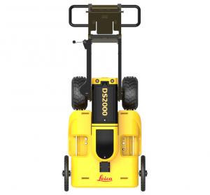
The Leica DS2000 is a popular Ground Penetrating Radar (GPR) system used for utility detection and subsurface imaging. The accuracy of the Leica DS2000 can vary based on several factors, including the soil conditions, the depth of the target, and the experience of the operator. Generally, the accuracy of GPR systems like the Leica DS2000 is influenced by the following factors: https://www.drainage-surveys.co.uk/
Antenna Frequency: The Leica DS2000 offers multiple antenna frequencies, such as 250 MHz, 500 MHz, and 700 MHz. Lower frequencies can penetrate deeper into the ground, but they may have lower resolution and accuracy compared to higher frequencies.
https://www.drainage-surveys.co.uk/SurveyingServices/UndergroundUtilitiesMapping
Depth of Investigation: The accuracy of the DS2000 tends to decrease with depth. At shallow depths, the system can provide higher accuracy, but as the depth increases, the uncertainty in target location may also increase.
Ground Conditions: The type of soil, presence of rocks, moisture content, and other subsurface properties can affect the accuracy of GPR data. Highly conductive or cluttered environments might reduce the system's accuracy.
Data Collection and Interpretation: The expertise and experience of the operator in data collection and interpretation play a significant role in the accuracy of GPR results. Proper data acquisition techniques and interpretation skills are crucial for achieving accurate subsurface imaging.
Calibration and Post-Processing: Proper calibration of the GPR system and appropriate post-processing of the collected data can enhance the accuracy of the results. https://www.drainage-surveys.co.uk/
Leica Geosystems, the manufacturer of the Leica DS2000, provides specifications and performance details in the product's technical documentation. It's essential to refer to the official product documentation or contact Leica directly for the most up-to-date and accurate information regarding the system's performance and accuracy specifications. https://www.drainage-surveys.co.uk/
Xray have added the above to join their older IDS detector duo 2.
The company have also invested in The RD8200 EML is a precision underground utility locator manufactured by Radiodetection, a leading company in the utility and pipeline locating industry. The RD8200 EML is designed to accurately and reliably locate buried utilities such as metallic pipes, cables, and conduits.
Key features of the RD8200 EML may include:
Multifrequency Capability: The RD8200 EML typically operates at multiple frequencies, allowing users to optimize the equipment for different utility types and ground conditions. https://www.drainage-surveys.co.uk/SurveyingServices/UndergroundUtilitiesMapping
High-Resolution Display: The device is equipped with a high-resolution display that provides real-time information about the located utilities and allows the operator to monitor the signal quality.
Automatic and Manual Gain Control: The locator may have both automatic and manual gain control options, enabling users to adjust the sensitivity to the specific site conditions.
Depth Estimation: The RD8200 EML can estimate the depth of the detected utilities, providing valuable information for excavation planning and utility mapping.
Signal Clarity and Signal Processing: The equipment is designed to offer clear and reliable signals, even in challenging environments with background interference.
Bluetooth Connectivity: Some models may offer Bluetooth connectivity, allowing data transfer to other devices or software for further analysis and reporting.
GPS Integration: Depending on the model and configuration, the RD8200 EML might have GPS integration to provide accurate location data for mapping purposes. https://www.drainage-surveys.co.uk/SurveyingServices/UndergroundUtilitiesMapping
Ergonomic Design: The device is designed to be lightweight and user-friendly, making it easy to operate for extended periods.
Various Accessory Options: Radiodetection typically offers a range of accessories for the RD8200 EML, such as different types of antennas, signal clamps, and carry cases.
The RD8200 EML is commonly used by utility locating professionals, construction companies, surveyors, and other industries involved in excavation projects or utility management. It helps prevent accidental damage to buried utilities during construction and excavation activities and assists in accurately mapping underground infrastructure. https://www.drainage-surveys.co.uk/
As technology and product specifications can change over time, it's essential to refer to the manufacturer's official website or product documentation for the most up-to-date information on the RD8200 EML and its capabilities.
https://www.drainage-surveys.co.uk/SurveyingServices/TopographicalAndMeasuredSurveys
GPS Land Topographical Surveying.
Once our professional utility surveyors Adam Page and Charlie page use the above equipment to locate all buried services on the ground they would then operate the GeoMax Zenith40 is a GNSS (Global Navigation Satellite System) receiver produced by GeoMax, a brand known for its geospatial solutions in the field of surveying and construction. The Zenith40 is designed to provide accurate and reliable positioning data for a wide range of surveying and mapping applications.
Key features of the GeoMax Zenith40 GPS receiver may include:
Multi-Constellation Support: The Zenith40 receiver supports multiple satellite constellations, such as GPS, GLONASS, Galileo, and BeiDou. This multi-constellation capability allows for increased satellite availability and improved positioning accuracy, especially in challenging environments.
RTK and Post-processing: The GeoMax Zenith40 supports both real-time kinematic (RTK) positioning for high-accuracy real-time data collection and post-processing options for achieving even higher accuracy during data analysis and processing.
Centimeter-Level Accuracy: With RTK correction, the Zenith40 can achieve centimeter-level positioning accuracy, making it suitable for precision surveying tasks.
Long Range Communication: The receiver may offer long-range communication options such as UHF (Ultra High Frequency) radio, GSM (Global System for Mobile Communications), or Bluetooth, allowing seamless communication between the base and rover units.
Data Logging and Internal Memory: The Zenith40 may have internal memory to store raw data and log data points during surveying, ensuring data continuity and security. https://www.drainage-surveys.co.uk/SurveyingServices/TopographicalAndMeasuredSurveys
IP68 Rating: The GeoMax Zenith40 is often built to withstand harsh environmental conditions, with an IP68 rating for dust and water resistance.
If you require any Utility Mapping Surveys to PAS128 Standard then please contact the team on.
Website - https://www.drainage-surveys.co.uk/
Email - info@drainage-surveys.co.uk
Surrey Office
01483 666795
London Office
0208 1111 221
MIke Brett
Cadmap Ltd
1483429385 ext.
email us here
Legal Disclaimer:
EIN Presswire provides this news content "as is" without warranty of any kind. We do not accept any responsibility or liability for the accuracy, content, images, videos, licenses, completeness, legality, or reliability of the information contained in this article. If you have any complaints or copyright issues related to this article, kindly contact the author above.


