Cadmap Elevate Design Projects with Advanced Utility Surveying Technology & Methods for Accurate Land Insights
Unveiling the Future of Subsurface Exploration with Cutting-Edge Ground-Penetrating Radar Technology!
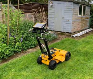
The Team at Cadmap Limited are using ground penetrating radar (GPR) along with radio-detection methods to enable clients to design with confidence. Unveiling Buried Services with Utility Mapping for a Clearer Path to Infrastructure Excellence!"
Overlaying a topographical survey on a utility survey can offer several benefits, providing a more comprehensive understanding of the subsurface and surface conditions. Here are some advantages of combining topographical and utility surveys:
Site Understanding:
Benefit: By overlaying a topographical survey on a utility survey, you gain a holistic view of the site. This integration allows you to understand both the surface features (elevation, terrain) and the subsurface infrastructure (utilities).
Application: Architects, engineers, and planners can make more informed decisions when designing projects that require knowledge of both surface and subsurface conditions.
Conflict Identification:
Benefit: Overlaying topographical and utility data helps identify potential conflicts between surface features and underground utilities.
Application: This is crucial for avoiding clashes during construction, minimizing the risk of damaging utilities, and ensuring that surface structures align with the subsurface infrastructure. https://cadmap.co.uk/
Optimised Design and Layout:
Benefit: Integrating topographical and utility surveys aids in optimizing the design and layout of infrastructure projects.
Application: Engineers can use this integrated data to plan the most efficient routes for utilities, taking into account the existing topography and minimizing the need for extensive modifications to the landscape.
Risk Mitigation:
Benefit: The combination of topographical and utility surveys helps in better risk assessment and mitigation.
Application: Understanding the relationship between surface features and utilities allows project managers to implement strategies that reduce the risk of construction delays, accidents, and unexpected challenges. https://cadmap.co.uk/
Effective Communication:
Benefit: Overlaying surveys facilitates effective communication among project stakeholders.
Application: It provides a common visual reference point for discussions between utility companies, construction teams, and design professionals, fostering collaboration and reducing the likelihood of misunderstandings.
Efficient Resource Allocation:
Benefit: The integrated data enables more efficient resource allocation during construction.
Application: Contractors can plan excavation activities more precisely, minimizing disruptions, and optimizing the use of heavy machinery and labor.
Regulatory Compliance:
Benefit: Helps in meeting regulatory requirements related to construction and utility placement.
Application: By understanding the relationship between utilities and the environment, it becomes easier to comply with regulations regarding environmental impact, safety standards, and construction practices.
In summary, overlaying a topographical survey on a utility survey enhances the overall planning and execution of construction projects by providing a comprehensive view of both surface and subsurface conditions. This integrated approach contributes to improved safety, efficiency, and successful project outcomes. https://cadmap.co.uk/surveying/pas128-utility-surveys
Cadmap Limited frequently provide Utility Mapping Surveys to PAS128 standards.
https://cadmap.co.uk/surveying/pas128-utility-surveys
PAS 128 is a British standard that provides guidelines for subsurface utility engineering (SUE) to improve the accuracy and reliability of utility information. It defines different quality levels (QL) to categorize the information obtained about underground utilities. Here's a brief overview of the PAS 128 levels:
Quality Level D (QL-D): Desktop Utility Record Search
Relies on existing utility records and historical information.
Provides an initial overview of utilities in the area.
No site visit is conducted.
Quality Level C (QL-C): Site Reconnaissance
Involves a visual inspection of the site to identify visible utility features.
Complements data obtained from QL-D with on-site observations.
Quality Level B (QL-B): Remote Detection
Utilizes geophysical methods (e.g., ground-penetrating radar, electromagnetic locators) to detect utilities.
A non-intrusive method that provides more detailed information.
Quality Level A (QL-A): Verification by Physical Exposure
Requires physical exposure through excavation to verify the location and attributes of utilities.
Provides the highest level of accuracy but is the most intrusive method.
Quality Levels A1, A2, A3, and A4 (QL-A1 to QL-A4): Precision Levels for Surveyed Data
These sub-levels differentiate the precision of surveyed data within QL-A, ranging from the highest precision (A1) to the lowest (A4).
These quality levels help standardize the process of collecting, managing, and communicating subsurface utility information. The goal is to improve safety, reduce risks during construction or excavation, and enhance overall project efficiency by providing accurate and reliable data about the location and characteristics of underground utilities.
It's important to choose the appropriate quality level based on the project requirements and goals.
If you require any of the below surveys please get in touch with Cadmap Limited at info@cadmap.co.uk or call 01483 429385
Mr Andrew Finn
Cadmap Land Surveyors & Building Surveyors & Utility Surveyo
+44 20 3174 2067
info@cadmap.co.uk
Visit us on social media:
Facebook
Twitter
LinkedIn
Instagram
YouTube
Cadmap Video for 3D Laser Scanning.
Legal Disclaimer:
EIN Presswire provides this news content "as is" without warranty of any kind. We do not accept any responsibility or liability for the accuracy, content, images, videos, licenses, completeness, legality, or reliability of the information contained in this article. If you have any complaints or copyright issues related to this article, kindly contact the author above.


