AGIS MDDL Can Be Used In The Hurricane Ida Response Effort
AGIS MDDL Is The State of the Art Common Operating Picture software
AGIS MDDL gives all participants the overall picture and shows how their contributions affect the operation - in real time.”
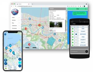
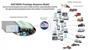
WASHINGTON, DC, US, September 1, 2021 /EINPresswire.com/ -- In a major disaster like Hurricane Ida, emergency responders may come from multiple agencies and from other states carrying disparate communication tools that work on different networks, channels, frequencies, encryption keys, etc. The AGIS website enables real-time, situational-awareness between all smartphone, Tablet and PC users to create a scalable C4I Common Operational Picture - or COP - system of the mapped area and the precise location of all responders. — Malcolm K. Beyer, CEO
Hurricane Ida responders can right now establish a COP with those in your organization or others and PTT. Simply go to www.liferingfirstresponder.com and register. You will be automatically approved. No Cost or Commitment.
Simply stated, Operational/Situational Awareness can be the difference between mission success and failure, sometimes life or death. First Responders, National Guard, Law Enforcement Personnel, EMTs and others must be able to communicate between themselves and centralized Command and Control.
In order to achieve information dominance at the scene and to quickly and efficiently affect communications between disparate organizations, AGIS’ innovative COP software can be deployed in a timely and cost effective manner. AGIS software architecture leverages Commercial Off The Shelf (COTS) hardware such as PCs, smartphones and Tablets. As these are carried by a great many people, devices and users can easily become sensors on an ad-hoc network and be used for the purpose of information collection, sharing and action.
Integrated Digital Data, Voice and Video are all encrypted within a single application. In addition, AGIS connectivity is not dependent on one single air-interface. AGIS MDDL supports myriad communications modalities including: Cellular, Land Mobile Radio, Satellite, IP- based Comms and more. When all network participants have the COP and capability to rapidly and effectively exchange data, voice, and video, everyone’s safety and operational effectiveness are greatly increased.
Digital Communication requires significantly less bandwidth than standard cellular and radio communication. And Digital has proved itself, time and again, by continuing to function during 9/11, Katrina, Sandy Hook, and the Boston Marathon. AGIS software equips all users with vital, up-to-date, position location information (PLI). The PLI includes: GPS status, GPS location, heading, speed, and previous locations.
How the System Works
With AGIS MDDL software, separate agencies can join groups to create a Common Operational Picture by collaborating, sharing, and refining relevant information. Users may join multiple groups to communicate with many other users, even from other agencies or organizations.
AGIS MDDL lets all participants see the overall picture and how their contributions affect the operation as it progresses. This knowledge reduces the level of constant oversight that incident commanders need to exercise over a large amount of responder groups.
This software was initially implemented for cellular use as it enabled AGIS to efficiently and effectively transmit the COP and very large video files from UAVs and other sources to the First Responder at the tip of the spear. AGIS has been working with U.S. DoD Joint Chiefs of Staff J6 for the past 9 years to achieve this goal by using high speed cellular communications. Map and satellite imagery is provided by various sources including the NGA, ESRI, and over 50 other sources.
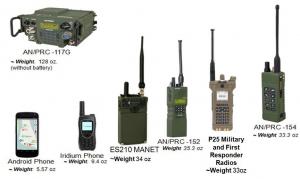
Project 25 (P25) – is the result of a collaboration of a variety of U.S. government agencies to establish a set of radio standards intended for use in emergency situations. The AGIS COP is able to operate in a P25 environment by using a connection, like USB cables that connect Android smartphones to P25 radios. Most P25 radios (e.g. the Motorola APX™ 7000 and SRX™ 2200) operate either in a conventional Peer-to-Peer Network or in a larger Trunk Network, although the P25 data rate is rather low.
AGIS’ design allows for efficient operation in this P25 environment through its use of UDP unicast, multicast or broadcast technology. AGIS provides the flexibility -- for urban and rural environments. In remote areas where cellular is not available, an Android Smartphone may use the P25 radio and access low speed networks. In fact, AGIS software is capable of creating a COP network even when some users are on Cellular, while others use P25 radios.
Real Time Capabilities Provide the Following Functions to All Users:
* Display of Participant Locations on a Color Map
* Over 80 Map Types and Satellite Imagery are Supported to include Digital Globe
* Location and Status Information is Automatically Transmitted between Participants to include:
o Latitude
o Longitude
o Speed
o Range
o Battery and Cell Status
* Participants Communicate through the use of:
o Voice, Text and Photo Messaging
o Emergency Alerts
o Entry of Geo-referenced symbols by touching the map and selecting the appropriate symbol
o Streaming Video - FMV (Full Motion Video)
o White Board
o Chat
o Push To Talk (PTT)
* Symbols are Customizable for Military or Civilian Use
* Custom Reports (i.e. MEDEVAC, IED, Spot Report)
* Display the location of all symbols regardless of zoom level
* Participant History Trails
* Tracking the Movements of Objects and Groups
In addition to the functions listed above, Real Time Capabilities provide these functions to PC Users:
* Issue Commands (Response Required)
* Create/Control Geo-Fences
* Display of up to 8 videos in a simultaneous view
* Display large amounts of synchronized data simultaneously on a COP
* Control of the Server (if a Server is used).
George Barros
Advanced Ground Information Systems (AGIS), Inc.
+1 571-766-8292
email us here
Information Exchange Occurs In Real Time Among All Participants
Legal Disclaimer:
EIN Presswire provides this news content "as is" without warranty of any kind. We do not accept any responsibility or liability for the accuracy, content, images, videos, licenses, completeness, legality, or reliability of the information contained in this article. If you have any complaints or copyright issues related to this article, kindly contact the author above.


