Advanced Low-Cost UAV SWARM Tracking
AGIS, BCF, and McQ Team Provides an Integrated UAV SWARM Tracking Capability designed to be integrated with other systems
The innovative solution provides a low-cost UAV SWARM Tracking tested solution that can operate as a standalone system that has previously been integrated with a combination of multiple radars and sensors to be part of a synchronized command and control (C2) platform that provides comprehensive tracking and video surveillance capabilities.
AGIS C-UAV System and a Complete Air Picture
The AGIS Counter-Unmanned Aerial Vehicle (C-UAV) system integrates Echodyne radars with FLIR cameras to provide video of the UAV and with McQ UAV detection sensors, placed well in front of the radar, provides alerting of the coming UAV or UAV SWARM. This data is then sent to weapon system operators to engage and destroy the hostile UAVs. AGIS’ software permits the system to be expanded to include multiple radars of different types, including long range radars, and 100's of McQ UAV approaching sensors. The combined system provides an integrated air picture of the area. AGIS’ software includes automatic reporting of the UAV location, speed and heading, and automatic intercept processing. For systems that include longer range radars, AGIS provides Link-16 processing that enables the Operators to receive and transmit aircraft data and to have the ability to issue engagement commands to the aircraft to engage hostile Air, Ground, and Sea Forces.
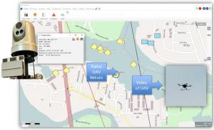
The AGIS Console operator can designate radar returns (UAV, Aircraft, Ground units or vehicles) to be automatically tracked by an associated video camera. When the operator hooks the radar return, it causes the associated video camera to slew to the correct Azimuth and Elevation angle to obtain video of the hooked return. Furthermore, the operator can select to have radar data and video transmitted to other C-UAV systems, to handheld Smartphones, and to Counter UAV Weapon Systems using Link-16, ATAK’s Cursor on Target (CoT) or AGIS’ Multi Domain Data Link (MDDL). The AGIS C-UAV system can receive simultaneous data from multiple types of radars and from other AGIS C- UAV systems or from longer range search radars, potentially creating a low-cost Forward Air Defense (FAD) system.
The EchoShield® and EchoGuard® radars are in use worldwide. The McQ sensors2 are in use with the U.S. and other militaries. The Marine Corps has selected McQ sensors for the Marine Corps Sensor Program of Record. BCF provides perimeter defense for the USAF and others. The AGIS Software, which integrates the system, is provided to the U.S. JCS Lab and others.
To enable post event analysis, all real-time data link transmissions, radar, camera video and UAV sonic detection data is recorded and becomes available for analysis and replay.
Other Applications and Use Cases
The AGIS / BCF Solutions / McQ Inc. partnership provides a versatile solution applicable in various scenarios, including:
• Airfields: Detection for unauthorized UAV or personnel intrusion.
• Border Security: Monitoring and securing national borders against unauthorized UAV and personnel incursions.
• Critical Infrastructure Protection: Safeguarding critical infrastructure such as power plants and government facilities.
• Event Security: Ensuring the safety and security of large public events.
For more information about AGIS and their innovative solutions, visit the AGIS website <https://www.agisinc.com> and the BCF Solutions website <https://bcfsolutions.com/security-communications/> and the McQ Inc. website <https://www.mcqinc.com/>
Malcolm K. Beyer, Jr.
Advanced Ground Information Systems (AGIS), Inc.
+1 561-744-3213
beyerm@agisinc.com
WATCH NOW: UAV Surveillance and Tracking with AGIS, BCF Solutions, McQ Inc. at http://www.youtube.com/watch?v=ygdmJ0sBPLo

1 https://www.echodyne.com/radar-solutions/echoguard/
2 https://www.mcqinc.com/products/
3 https://ndupress.ndu.edu/Media/News/News-Article-View/Article/3197193/countering-swarms-strategic-considerations-and-opportunities-in-drone-warfare/

