Expanded IP Surveys Outline an Additional 600m Strike Length to the Major Mineralized Corridor at Eloro Resources’ Iska Iska Project, Potosi Department, Southwestern Bolivia
- New chargeability high southeast of the MRE open pit indicates that the major mineralized structural corridor that is up to 800m wide extends a further 600m along strike to the southeast for an overall strike length of at least 2km. This new area has not been drilled.
- Chargeability highs correlate very well with areas of high-grade mineralization within the MRE. The chargeability anomaly southeast of the pit is very strong, which is a prime target potentially outlining additional higher-grade polymetallic (Ag-Zn-Pb) mineralization.
-
The Chargeability anomaly is open along strike and at depth as exploration work has still not defined the full limits of this remarkable mineralized system.
TORONTO, Jan. 29, 2024 (GLOBE NEWSWIRE) -- Eloro Resources Ltd. (TSX: ELO; OTCQX: ELRRF; FSE: P2QM) is pleased to announce that an expanded induced polarization/resistivity (IP/Res) survey now covers most of the Iska Iska Project, Potosi Department, Southwestern Bolivia. East-west lines have been completed every 200m across and southeast of the Santa Barbara mineral resource using a deep-penetrating array of 50m and offset 100m dipoles to obtain a depth of investigation approaching 400m. The new array and lower surface elevations make it possible to image mineralization at elevations below 3600m in an extension beyond the open southeastern side of the pit that defines the initial mineral resource estimate (“MRE”) (see Eloro press release dated October 17, 2023). In this survey, chargeability highs across the volume already drilled for the Santa Barbara MRE coincide with peaks in the grade of the polymetallic Ag-Zn-Pb mineralization expressed as silver equivalent.
Dr. Bill Pearson, P.Geo., Eloro’s Executive Vice President, Exploration commented: “We have had great success with our borehole IP/Res program correlating mineralization between the drillholes, but the surface IP/Res provides a 3-dimensional view well beyond where we have drill hole coverage. The new chargeability anomaly, extending southeastward from the open pit that defines the MRE, adds at least an additional 600m of potential strike length to the major mineralized structural corridor that is up to 800m wide for an overall strike length of at least 2km. This new target area has not been drilled. In addition, the chargeability anomaly southeast of the pit is very strong, suggesting that it is a prime target for outlining additional higher-grade polymetallic mineralization.”
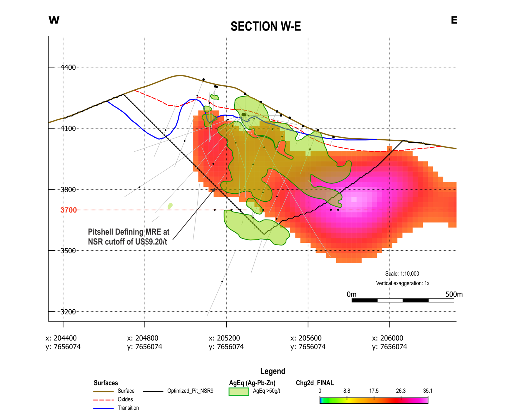
Figure 1 shows the same section that was reported in the Eloro press release dated January 11, 2024. Green solids indicate high grade mineralized zones where the silver equivalent grade is greater than 50 g Ag eq/t. These high-grade areas coincide very closely with high chargeability (> 20 mV/V), confirming the correlation of grade with borehole IP between drill holes inside the MRE pit.
The chargeability anomaly is open along strike and at depth as exploration work has still not defined the full limits of this remarkable mineralized system.
Figure 1. Cross Section along Line 56100N of the Chargeability Anomaly with areas with greater than 50 g Ag eq/t superimposed to show the very strong correlation. The strong anomaly to the southeast is largely outside the open pit defining the MRE and this area has not been drilled. Figures 2 and 3 show the location of the section line.

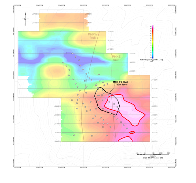
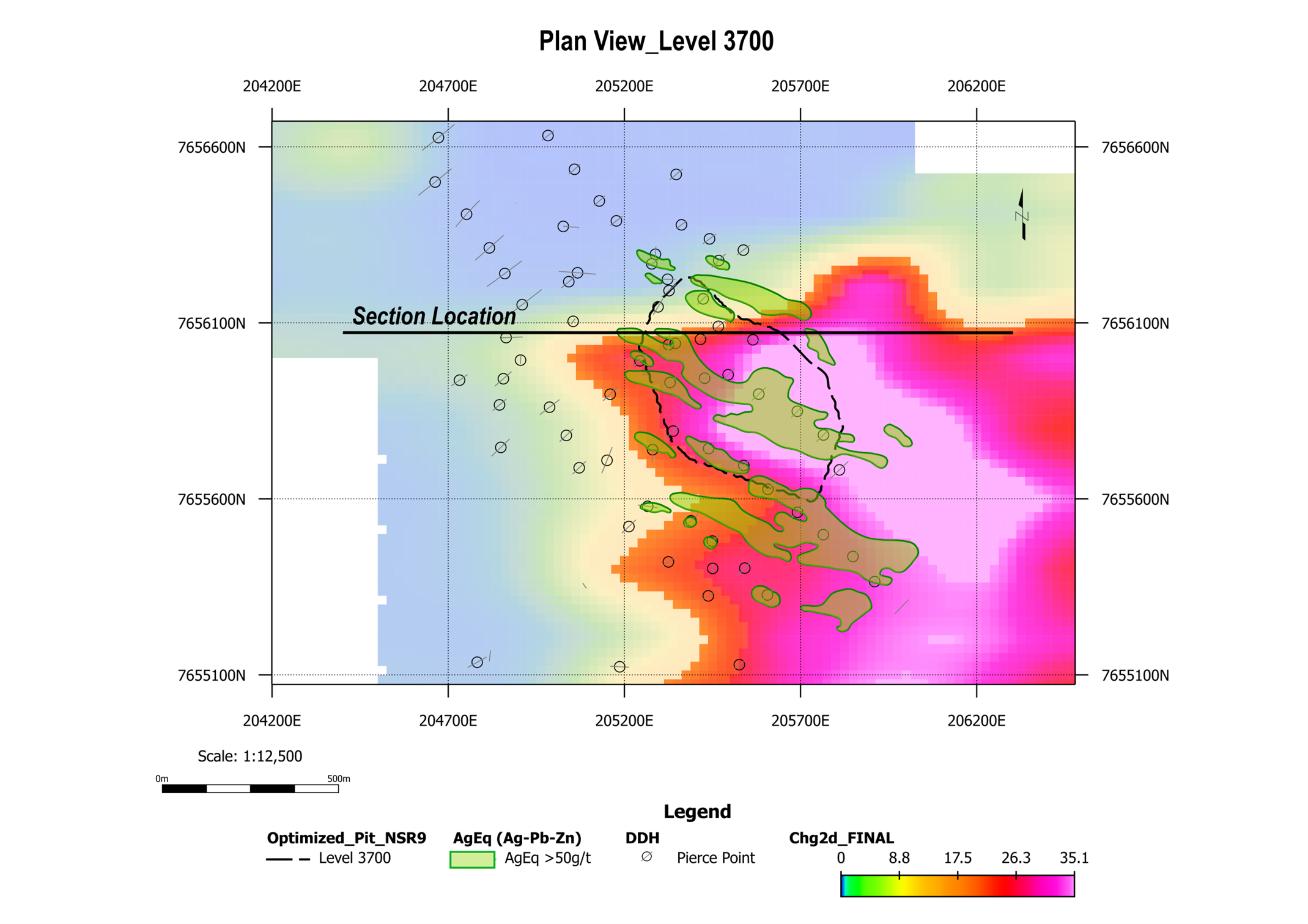
Figure 2 is a plan view of the model chargeability at an elevation of 3700 m where the highest chargeability outlined in red extends southeastward, well beyond the MRE open pit shown in black. Drill hole pierce points at 3700 m (grey circles) demonstrate that much of the high chargeability anomaly has not yet been drill tested. Figure 3 is the same plan showing the strong correlation of high-grade areas with the chargeability anomaly.
Figure 2: Plan map of Chargeability Model at 3700m elevation showing the extent of the chargeability anomaly southeast of the open pit defining the MRE. Pierce points of drill holes on the 3700 m elevation clearly show that this major anomaly is essentially untested by drilling.

Figure 3 is a Plan Map of the same Chargeability Model at 3700m elevation shown in Figure 2 with the contoured 50 g Ag eq superimposed showing the strong correlation of high-grade areas with the chargeability anomaly.

Qualified Person (“QP”)
IP/Res surveys were carried out by MES Geophysics using Eloro’s ELREC-Pro 10 channel IP receiver and GDD 3600 watt IP transmitter. Dr. Chris Hale, P.Geo. and Mr. John Gilliatt, P.Geo. of Intelligent Exploration provided the survey design, preparation of the maps and interpretation of data processed, and quality reviewed by Mr. Rob McKeown, P. Geo. of MES Geophysics. Messrs. Hale, Gilliatt and McKeown are Qualified Persons (“QP”) as defined under National Instrument 43-101 (“NI 43-101”).
The inaugural MRE for Iska Iska is outlined in the NI 43-101 Technical Report (see Eloro press release dated October 17, 2023) prepared by Micon International Limited. Independent QPs for the Technical Report are Charley Murahwi, P.Geo., FAusIMM, Richard Gowans, P.Eng., Ing. Alan J. San Martin, MAusIMM (CP) and Abdul Aziz, Drame, P.Eng., all of whom are independent QP’s as defined by NI 43-101. Mr. Murahwi completed site visits in January 2020 and November 2022.
Silver equivalent (Ag eq) grades are calculated using 3-year average metal prices of Ag = US$22.52/oz, Zn = US$1.33/lb and Pb = 0.95/lb and preliminary metallurgical recoveries of Ag = 88%, Zn = 87% and Pb= 80%.
Dr. Bill Pearson, P.Geo., Eloro’s Executive Vice President Exploration and a QP as defined by NI 43-101 has reviewed and approved the technical content of this news release. Dr. Pearson who has more than 49 years of worldwide mining exploration, development and production experience, including extensive work in South America, manages the overall technical program, working closely with Dr. Osvaldo Arce, P.Geo. General Manager of Eloro’s Bolivian subsidiary, Minera Tupiza S.R.L., and a QP in the context of NI 43-101, who has supervised all field work carried out at Iska Iska.
About Iska Iska
Iska Iska silver-tin polymetallic project is a road accessible, royalty-free property, wholly controlled by the Title Holder, Empresa Minera Villegas S.R.L. and is located 48 km north of Tupiza city, in the Sud Chichas Province of the Department of Potosi in southern Bolivia. Eloro has an option to earn a 100% interest in Iska Iska.
Iska Iska is a major silver-tin polymetallic porphyry-epithermal complex associated with a Miocene possibly collapsed/resurgent caldera, emplaced on Ordovician age rocks with major breccia pipes, dacitic domes and hydrothermal breccias. The caldera is 1.6km by 1.8km in dimension with a vertical extent of at least 1km. Mineralization age is similar to Cerro Rico de Potosí and other major deposits such as San Vicente, Chorolque, Tasna and Tatasi located in the same geological trend.
Eloro began underground diamond drilling from the Huayra Kasa underground workings at Iska Iska on September 13, 2020. On November 18, 2020, Eloro announced the discovery of a significant breccia pipe with extensive silver polymetallic mineralization just east of the Huayra Kasa underground workings and a high-grade gold-bismuth zone in the underground workings. On November 24, 2020, Eloro announced the discovery of the SBBP approximately 150m southwest of the Huayra Kasa underground workings.
Subsequently, on January 26, 2021, Eloro announced significant results from the first drilling at the SBBP including the discovery hole from 0.0m to 257.5m. Subsequent drilling has confirmed significant values of Ag-Sn polymetallic mineralization in the SBBP and the adjacent CBP. A substantive mineralized envelope which is open along strike and down-dip extends around both major breccia pipes. Continuous channel sampling of the Santa Barbara Adit located to the east of SBBP returned 164.96 g Ag/t, 0.46%Sn, 3.46% Pb and 0.14% Cu over 166m including 446 g Ag/t, 9.03% Pb and 1.16% Sn over 56.19m. The west end of the adit intersects the end of the SBBP.
Since the initial discovery hole DHK-15 which returned 29.53g Ag/t, 0.078g Au/t, 1.45%Zn, 0.59%Pb, 0.080%Cu and 0.056%Sn over 257.5m, Eloro has released a number of significant drill results in the SBBP and the surrounding mineralized envelope which along with geophysical data has defined an extensive target zone. On October 17, 2023, Eloro filed the NI 43-101 Technical Report outlining the initial inferred MRE for Iska Iska, prepared by Micon International Limited. The MRE was reported in two domains, the Polymetallic (Ag-Zn-Pb) Domain which is primarily in the east and south of the Santa Barbara deposit and the Tin (Sn-Ag-Pb) Domain which is primarily in the west and north. The Polymetallic Domain is estimated to contain 560Mt at 13.8 g Ag/t, 0.73% Zn & 0.28% Pb at an NSR cutoff of US$9.20 for potential open pit and an NSR cutoff of US$34.40 for potential underground. The majority of the mineral resource is contained in the constraining pit which has a stripping ratio of 1:1.
The Polymetallic Domain contains a higher-grade mineral resource at a NSR cutoff of $US25/t of 132 million tonnes at 1.11% Zn, 0.50% Pb and 24.3 g Ag/t which has a net NSR value of US$34.40/t which is 3.75 the estimated operating cost of US$9.20/t. The Tin Domain which is adjacent the Polymetallic Domain and does not overlap, is estimated to contain a mineral resource of 110Mt at 0.12% Sn, 14.2 g Ag/t and 0.14% Pb but is very under drilled.
The Company has completed a 5,267.7m definition drill program to upgrade and expand the higher-grade mineral resource in the Polymetallic Domain and has commenced a preliminary economic evaluation (PEA) led by Lycopodium.
About Eloro Resources Ltd.
Eloro is an exploration and mine development company with a portfolio of gold and base-metal properties in Bolivia, Peru and Quebec. Eloro has an option to acquire a 100% interest in the highly prospective Iska Iska Property, which can be classified as a polymetallic epithermal-porphyry complex, a significant mineral deposit type in the Potosi Department, in southern Bolivia. A recent NI 43-101 Technical Report on Iska Iska, which was completed by Micon International Limited, is available on Eloro’s website and under its filings on SEDAR. Iska Iska is a road-accessible, royalty-free property. Eloro also owns an 82% interest in the La Victoria Gold/Silver Project, located in the North-Central Mineral Belt of Peru some 50 km south of the Lagunas Norte Gold Mine and the La Arena Gold Mine.
For further information please contact either Thomas G. Larsen, Chairman and CEO or Jorge Estepa, Vice-President at (416) 868-9168.
Information in this news release may contain forward-looking information. Statements containing forward-looking information express, as at the date of this news release, the Company’s plans, estimates, forecasts, projections, expectations, or beliefs as to future events or results and are believed to be reasonable based on information currently available to the Company. There can be no assurance that forward-looking statements will prove to be accurate. Actual results and future events could differ materially from those anticipated in such statements. Readers should not place undue reliance on forward-looking information.
Neither the TSX nor its Regulation Services Provider (as that term is defined in the policies of the TSX) accepts responsibility for the adequacy or accuracy of this release.
Photos accompanying this announcement are available at:
https://www.globenewswire.com/NewsRoom/AttachmentNg/9b618cf9-6f02-4d2d-983d-e26bf07b0d7e
https://www.globenewswire.com/NewsRoom/AttachmentNg/fcec81a1-d0db-437d-ac32-14bc08cacfa5
https://www.globenewswire.com/NewsRoom/AttachmentNg/45d8082a-ea76-4c16-bfd9-f5fe22f85675

Figure 1
Cross Section along Line 56100N of the Chargeability Anomaly with areas with greater than 50 g Ag eq/t superimposed to show the very strong correlation. The strong anomaly to the southeast is largely outside the open pit defining the MRE and this area has not been drilled. Figures 2 and 3 show the location of the section line.
Figure 2
Plan map of Chargeability Model at 3700m elevation showing the extent of the chargeability anomaly southeast of the open pit defining the MRE. Pierce points of drill holes on the 3700 m elevation clearly show that this major anomaly is essentially untested by drilling.
Figure 3
Figure 3 is a Plan Map of the same Chargeability Model at 3700m elevation shown in Figure 2 with the contoured 50 g Ag eq superimposed showing the strong correlation of high-grade areas with the chargeability anomaly.
Legal Disclaimer:
EIN Presswire provides this news content "as is" without warranty of any kind. We do not accept any responsibility or liability for the accuracy, content, images, videos, licenses, completeness, legality, or reliability of the information contained in this article. If you have any complaints or copyright issues related to this article, kindly contact the author above.


