Blue Marble Geographics Releases Version 25 of Global Mapper with New Tool for Creating an Optimal Flattened Site Plan
Version 25 includes an additional functionality to the Calculate Flattened site plan tool, automatic feature styling for distinguishing vector layers, and more.
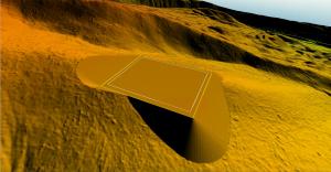
The Create a Flattened Site Plan tool is popular for preplanning the best location, elevation, and required earthworks for the creation of a flat surface in a terrain layer. A new option in the tool, Create an Optimal Flattened Site Plan, can take advantage of any flexibility in the exact placement and orientation of the flattened site. Global Mapper assesses the terrain in a specified location to find the optimal placement and orientation for the site to minimize cut and fill costs.
Global Mapper’s Watershed tool performs a watershed analysis to model the flow of water across a terrain layer, measuring flow accumulation and direction and delineating watershed boundaries. Version 25 pushes this tool even further by adding support for vector features to be used as obstructions or modifications to more accurately model how potential objects impact flow.
“User interface updates for enhanced support of high-resolution display and Analysis menu reorganization in Global Mapper version 25 accompany some highly requested analysis tool updates,” stated Mackenzie Mills, Assistant Product Manager. "These improvements allow watershed creation to consider vector feature obstructions and add the ability to optimize the placement of flattened site plan terrain creation.”
To help visually distinguish overlapping or similar layers, a new autostyling option is available to assign colors by default to vector features of the Unknown Feature type. Global Mapper uses feature types as one method of applying preset styles to vector layers. This update applies to the default feature type to help visually differentiate vector layers that may otherwise be similar.
The Analysis menu has been split into four based on the type of data used during processing: Lidar, Raster, Terrain, and Vector. The Terrain menu focuses on raster layers that require elevation data. The Raster menu includes tools that can be applied to other layers, including images, topographic maps, etc.
Other updates to version 25 of Global Mapper include the improved display behavior on high-resolution screens. Global Mapper is now better able to take full advantage of high DPI displays. Menus and dialogs will more accurately adjust when moved between monitors of differing resolutions and scales.
For more information about Global Mapper Pro and to download a free application trial, visit https://www.bluemarblegeo.com/global-mapper-pro.
###
As a leader in GIS and software development, Blue Marble Geographics® provides professional-grade tools to GIS users at every level. Founded in 1993, Blue Marble’s expertise spans the geospatial technology sector with a particular focus on coordinate conversion and management, lidar and photogrammetric point cloud processing, and user-driven product development.
Blue Marble’s products include Geographic Calculator®, the industry standard for precise spatial data conversion and advanced coordinate system management; Global Mapper®, an all-in-one GIS application with a comprehensive array of data processing and analysis tools; and Global Mapper Pro®, a suite of advanced tools for optimizing workflow efficiency, and processing lidar and photogrammetric point clouds from drone-captured images. All of these desktop tools are also available as software developer toolkits and libraries.
For nearly three decades, Blue Marble’s products have been used and trusted by organizations around the globe — including government agencies, universities, and Fortune 500 companies. For more information, visit: www.bluemarblegeo.com
Contact Information:
Cíntia Miranda, Director of Marketing
Blue Marble Geographics
Hallowell, ME, USA
cintiam@bluemarblegeo.com
800-616-2725
+1(207) 622-4622
Cintia Miranda
Blue Marble Geographics
+1 207-622-4622
email us here
Visit us on social media:
Facebook
Twitter
LinkedIn
Instagram
YouTube
Legal Disclaimer:
EIN Presswire provides this news content "as is" without warranty of any kind. We do not accept any responsibility or liability for the accuracy, content, images, videos, licenses, completeness, legality, or reliability of the information contained in this article. If you have any complaints or copyright issues related to this article, kindly contact the author above.


