Blue Marble Geographics Releases Global Mapper Pro v25 with New Point Cloud Custom Classification Training Tool
Version 25 includes a new custom point cloud classification training tool, existing tools redesign, and significant processing speed improvements.
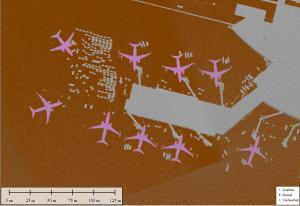
The Automatic Point Cloud Analysis tool is the new hub of point cloud classification and extraction in Global Mapper Pro. This integrated tool allows users to manage automatic classifications, segmentation, and feature extraction from one window, providing the ability to share settings and run multiple processes simultaneously. Also included are new segmentation processes for ground and noise classifications, such as the segmentation-based “Max Likelihood” methods, which were previously only available for non-ground points, but are better tailored for modern point cloud generation and collection approaches.
A new Custom Feature Classification (Beta) tool gives users the ability to define custom classifications based on user-created training samples. Users can create their automatic point cloud classifications and train Global Mapper to find specific objects in their point clouds. These settings can also be applied to further train existing classification methods to tailor the tool for particular datasets and workflows.
A newly added Least Cost Path tool provides a terrain analysis method for finding the shortest and most efficient path between locations. By iterating through all possible options, it identifies the best route between specified point features across a terrain layer based on minimized terrain slope angle and avoiding unwanted areas. This simple yet powerful analysis can connect two locations, map multiple locations into a single path, or discover the most accessible site.
“The latest updates to Global Mapper Pro include new features and updates to various existing functionalities,” stated Jeffery Hatzel, Product Manager. “Least cost path analysis and elevation QC tools further expand Global Mapper's comprehensive terrain analysis tools. Numerous point cloud analysis updates, including the ability to train and identify custom classifications, continue to solidify Global Mapper Pro as an essential and groundbreaking product for any advanced GIS workflow.”
Other updates to version 25 of Global Mapper include the ability to compare kriging outputs to control data as cross-validation and improvements to the creation of estimated tree footprints extracted from point clouds. A few of the new tools are expansions of existing popular ones, such as Raster Painting, which allows for editing image and raster layers, and Elevation QC for applying vertical adjustments based on ground control points.
To learn more about the new features available in standard and Pro versions of Global Mapper v25, register and join us at upcoming webinars ‘What’s new in Global Mapper Standard v25.?” webinar on Wednesday, September 27, 2023, and ‘ What’s new in Global Mapper Pro v.25?” on October 4, 2023.
For more information about Global Mapper Pro and to download a free application trial, visit https://www.bluemarblegeo.com/global-mapper-pro.
###
As a leader in GIS and software development, Blue Marble Geographics® provides professional-grade tools to GIS users at every level. Founded in 1993, Blue Marble’s expertise spans the geospatial technology sector with a particular focus on coordinate conversion and management, lidar and photogrammetric point cloud processing, and user-driven product development.
Blue Marble’s products include Geographic Calculator®, the industry standard for precise spatial data conversion and advanced coordinate system management; Global Mapper®, an all-in-one GIS application with a comprehensive array of data processing and analysis tools; and Global Mapper Pro®, a suite of advanced tools for optimizing workflow efficiency, and processing lidar and photogrammetric point clouds from drone-captured images. All of these desktop tools are also available as software developer toolkits and libraries.
For nearly three decades, Blue Marble’s products have been used and trusted by organizations around the globe — including government agencies, universities, and Fortune 500 companies. For more information, visit: www.bluemarblegeo.com
Contact Information:
Cíntia Miranda, Director of Marketing
Blue Marble Geographics
Hallowell, ME, USA
cintiam@bluemarblegeo.com
800-616-2725
+1(207) 622-4622 ext. 1132
Cíntia Miranda
Blue Marble Geographics
207-622-4622
email us here
Visit us on social media:
Facebook
Twitter
LinkedIn
Instagram
YouTube
Legal Disclaimer:
EIN Presswire provides this news content "as is" without warranty of any kind. We do not accept any responsibility or liability for the accuracy, content, images, videos, licenses, completeness, legality, or reliability of the information contained in this article. If you have any complaints or copyright issues related to this article, kindly contact the author above.


